Notice: iPad/iPhone WiFi Issues
If you are using iOS 15 or later on your iPad/iPhone and experiencing problems connecting to WiFi devices, please see these Instructions.
Key Features and Benefits
Datasheet
Download a datasheet for SEAiq Pilot
SEAiq Pilot provides navigation tools designed for pilots. It is used in ports and pilotage areas around the world.
- Comprehensive navigation and piloting features: routes, tracks, VRM, EBL, clearing lines, mariners notes, etc.
- Support for all major platforms: Apple iPads/iPhones, Windows, and Apple MacOS.
- Support for a wide range of pilot plugs and PPUs. Connectivity varies by platform; see compatibility.
- Support all standard chart formats including S-63, S-57, iENC, and BSB/KAP.
- Automatic chart download/update for vector charts from NOAA and US Army Corps of Engineers.
- Automatic chart download/update from PRIMAR, ChartWorld, Admiralty (UKHO).
- NMEA and AIS: Support for WiFi pilot plugs and PPUs. Bluetooth plugs are supported on most platforms. Connect to both pilot plug and to shore-based AIS at the same time. Free AIS world-wide data feed.
- NMEA/AIS record and playback: Automatically record all vessel movements and playback later at normal or 10x speed
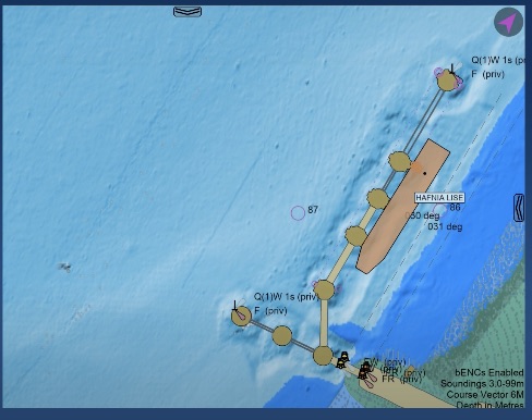
- Powerful true-scale vessel display: Predicted course, predicted vessel position, swept path, AIS vessel types, estimated squat and pivot point.
- Real-time status bar selects from 35 panels to display key information based on situation.
- Docking Aids: Show distance and speed to user selected fenders and single point moorings. Both graphical and textual displays.
- Pilot Logbook: Record events during pilotages. Automatically saves time, own-ship status, route, and nearby AIS targets. Add camera images and screenshots. Print logbook from iPad or archive via email and other methods.
- Collision Avoidance: graphical CPA, BCD, meeting points, trial ROT, trial SOG, alarms.
- Grounding Avoidance: depth contours, tidal adjustment, hi-res bathymetric ENCs.
- Route planning: ETAs, goal times, speed limits, passing restrictions.
- Mariners Tools with VRM, EBL, clearing lines, and mariners notes. Mariners notes have choice of over 50 symbols. Lines or polygons in user-selected colors and styles.
- Simple import of existing routes. Supported formats include GPX, RTU, RT3, RTZ, CSV, Nacos Platinum, and Sam Electronics.
- Additional features: weather, anchor alarm, free satellite imagery charts, etc.
- All documentation (both online and PDF) is available here
Details
Read more about features here.